
State Natural Area — Baraboo Hills
Ableman’s Gorge State Natural Area
Rock Springs, Wisconsin • About 8 miles west of Devil’s Lake State Park • No state park vehicle pass required
Fast takeaway: Two very different trails share this property. The gorge floor trail is short and nearly flat — but it puts you in front of Van Hise Rock, a single pillar where Charles Van Hise worked out foundational principles of structural geology around 1900. The bluff trail climbs 272 feet over 1.5 miles to the top of the same quartzite walls. No state park vehicle pass required.
Ableman’s Gorge is where structural geology became a science. A 15-foot pillar at the north parking area — Van Hise Rock — exposes three rock layers folded and tilted nearly vertical during a mountain-building event 1,650 million years ago. The outer layers are massive pink quartzite. The middle layer is phyllite, a metamorphosed shale. Because phyllite contains flat minerals aligned during metamorphism, it shows visible cleavage planes angling through the dark band. The quartzite, made of quartz rather than planar minerals, does not. Around 1900, Charles Van Hise used the relationship between cleavage and bedding in this pillar to decode the geometry of the the Baraboo Syncline. His colleagues placed a bronze plaque here in 1923.
The gorge also records what happened 500 million years later. By Cambrian time the quartzite had been eroded into a rocky island rising from a tropical sea — Wisconsin then sat south of the equator. Storm waves broke chunks from the cliffs, tumbled them in the surf, and buried them under coastal dunes. That debris hardened into the sandstone and conglomerate now surrounding the ancient island. The contact between the 1.65-billion-year-old quartzite and the overlying Cambrian rock is visible in the gorge walls — an unconformity representing more than a billion years of missing time.
Plan your visit
Location & Directions
From Baraboo, take Highway 136 west approximately 8 miles to Rock Springs. Two small pull-off parking areas sit along the river side of the road. The lower Trailhead is directly across the road from these small lots. Another parking area is tucked up against the bluff near the river bridge beyond Van Hise Rock. This is where the upper trailhead starts. No roadside parking — vehicles may be fined or towed.
Access & Hours
Hours standard for Wisconsin SNAs. Verify posted signage before your visit.
Amenities
No facilities on-site. Nearest restrooms in Rock Springs village, approximately 0.5 miles east.
Pass & Fee
Ableman’s Gorge is a standalone DNR-owned State Natural Area, not part of the Devil’s Lake State Park system. No vehicle sticker or daily admission fee applies.
Fee status verified June 2026. Confirm before your visit.
Gorge Floor Trail
A short loop at the base of the quarry walls. Key stops include the old quartzite quarry exposures, historic structures, the Van Hise Rock plaque at the north parking area Rock climbing on the cliffs is prohibited.
Bluff Trail
A separate trail climbs from the gorge floor to the top of the bluff above the quarry walls. Wooded throughout, with a sustained climb concentrated in the lower half. The ridge gives a perspective on the same geology from above. Trail can be overgrown later in the season. No fencing at the top — steep drop-offs present.
Trail length per AllTrails (1.5 mi). Verify with GPS if you record this trail. Some visitors report 1.5–2 miles depending on start point.
Parking
Both lots are small pull-offs along Highway 136. They rarely fill, but this is a narrow rural highway — do not park on the shoulder. The south lot also serves as access for artesian well users; don’t block the commercial truck lane.
On-the-ground details
Best Time to Visit
- Spring (March–May) offers the clearest views of the quarry walls before full leaf-out, and the artesian well area is especially lush.
- Crowds are light year-round. This is not a high-volume destination — you will likely have the gorge to yourself on weekdays.
- The bluff trail can become overgrown and difficult to navigate by late summer. Early season is the better window if the bluff is your goal.
- Winter access is possible; the quartzite walls are striking with snow and ice, but the bluff trail becomes hazardous when icy.
Good to Know
- The artesian well at the south lot has been used by locals for generations. Visitors may fill water bottles; leave the commercial truck access clear.
- The drive from Baraboo on Highway 136 runs through the heart of the Baraboo Hills — the geology context starts before you arrive.
- No cell service in the gorge. Download an offline map before leaving. The AllTrails listing has a downloadable GPX track for the bluff trail.
- The top of the gorge can be accessed by driving up 2nd st. from behind the rockface, however there is no parking.
Rules & Restrictions
- Rock climbing is prohibited on all cliff faces.
- Dogs are permitted, unless stated otherwise. Verify current rules on posted signage.
- Collecting rocks, fossils, or plant material is prohibited — this is a protected State Natural Area.
- Camping and fires are not permitted.
- Stay on designated trails. The gorge slopes above the quarry are ecologically sensitive.
- Pack out all trash. No waste receptacles on-site.
Managed by the Wisconsin DNR and University of Wisconsin. Rules verified June 2026 — confirm posted signage on-site. DNR: 608-266-2621.
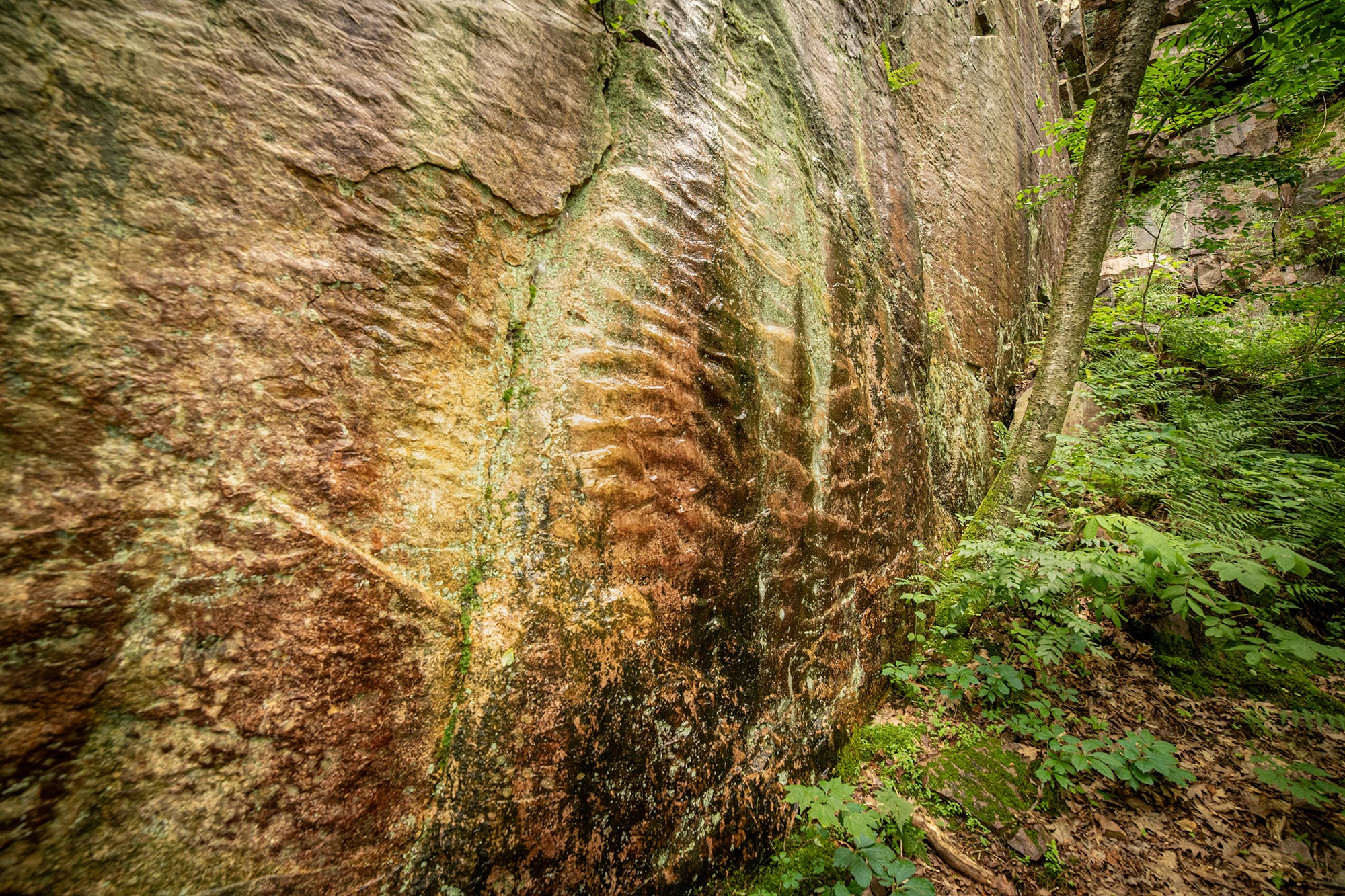
Ripple mark (recently collapsed) in the quartzite once marked the former sea bed.

Van Hise Rock — named for the geologist who made this site famous
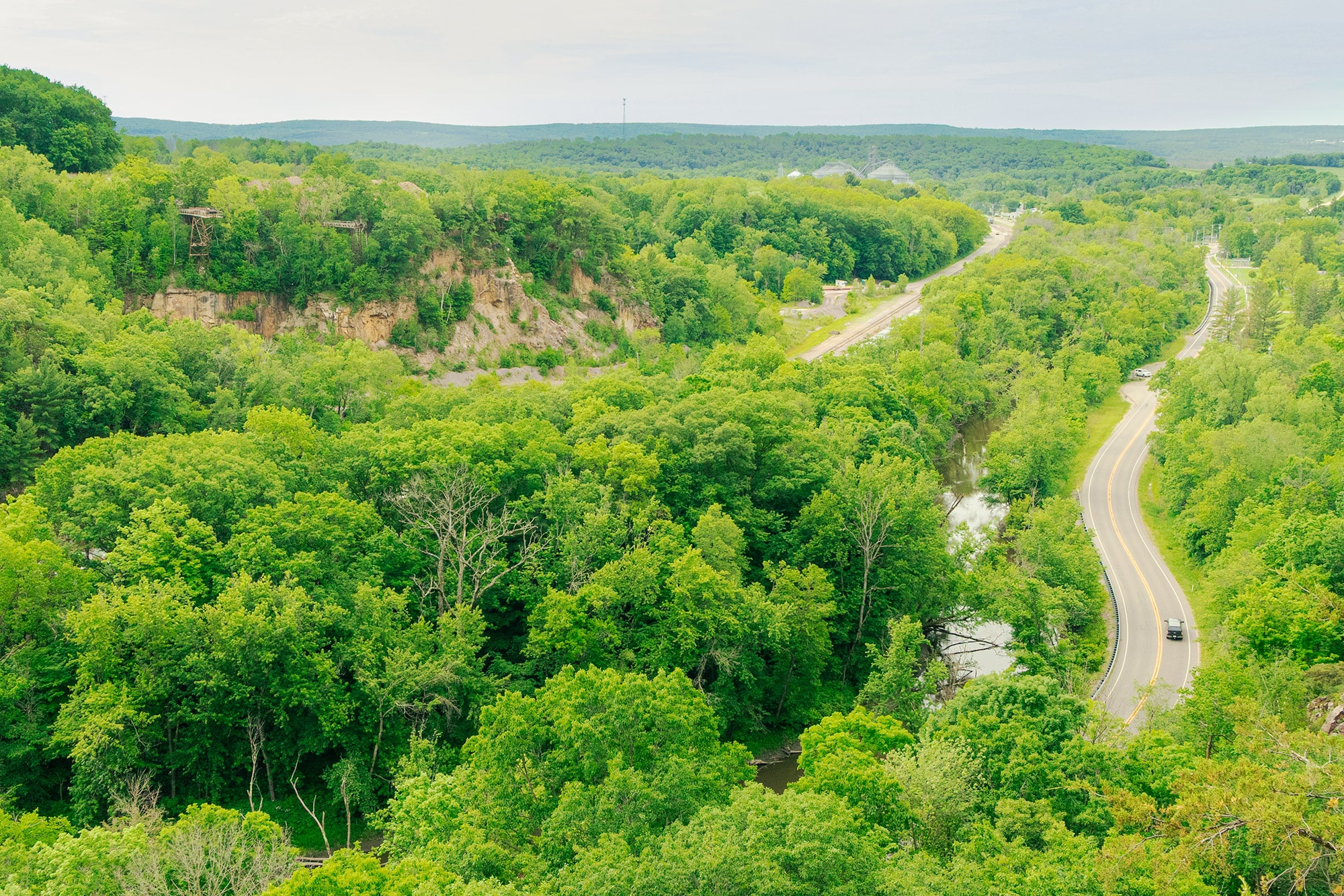
View from the bluff trail above the quarry walls