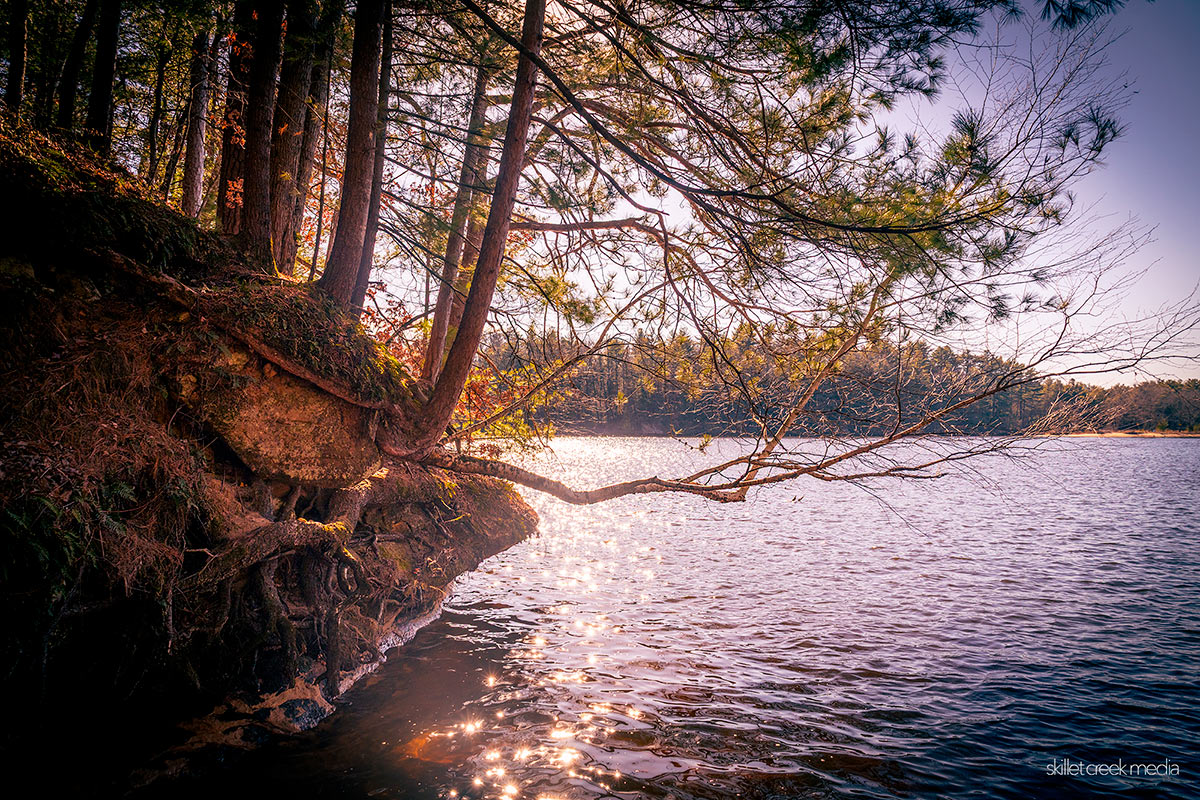
Our relationship with nature in Wisconsin Dells has always been a bit complicated. It’s hard…
So, you’ve conquered the Baraboo Hills and marveled at Devil’s Lake State Park and Parfrey’s Glen on our Day 1 itinerary. What’s up for day 2? Well, it depends on what you’re after, but let me share our approach.
My wife and I are always on the hunt for those natural wonders unique to wherever we’re visiting. At the same time, we’re all about keeping the stress levels down (as much as possible, anyway – sometimes that’s easier said than done!) so we don’t want to pack too much into a day. With that in mind, we’ve crafted a day 2 itinerary that we think hits all the right notes.
Now, before I dive in, I should be clear that there are tons of other natural attractions and activities in our area that could have been featured here (And probably have been featured in past articles). We just couldn’t squeeze them all into this single weekend. We could have chosen to do less driving on day 2 as well, but our goal is to provide some diverse experiences. If hiking’s your thing, there are some fantastic sections of the Ice Age Trail we haven’t even touched upon. More of a cycling enthusiast? The 400 State Trail or The Great Sauk Trail might be calling your name for day 2. But if you’re just looking to soak in the diversity of our natural areas, stick with me.
Roche-A-Cri State Park
Alright, rise and shine! Grab a snack and pack your lunch, we’re heading north today. From Devil’s Lake State Park or Baraboo, point your compass northward for about an hour’s drive (56 minutes if you’re coming from Devil’s Lake SP, to be precise). Our destination? The intriguing Roche-A-Cri State Park.
Google Map Link – Directions From Devil’s Lake
Aim to arrive around 8 AM, and prepare to be amazed. As you enter the central sands region of Wisconsin, you’ll notice a massive change in the landscape. The stars of the show here are the sandstone outcrops – ancient islands in what was once glacial Lake Wisconsin. You could easily spend days exploring all the incredible formations in the area including Mill Bluff State Park, Rabbit Rock, and more, but Roche-A-Cri gives you a perfect taste of this sandy wonderland.
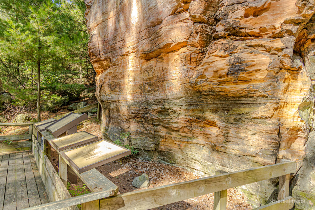
Native American Petroglyphs and Pictographs
First on your must-see list are the pictographs at the base of the mound. These ancient artworks are believed to be the handiwork of Ho-Chunk ancestors, with the petroglyphs dating back to before 900 AD and the pictographs appearing 400-500 years ago. Take a moment to ponder the history etched and painted into the stone.
Roche-A-Cri Mound Stairway
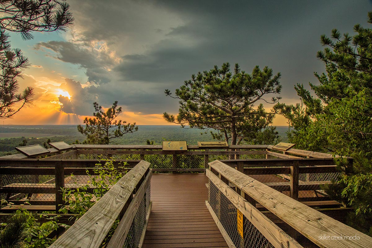
Next up, if you’re feeling energetic, tackle the 303-step stairway to the top of the 300-foot Roche-A-Cri Mound. Trust me, the panoramic views are worth every step. The stairway’s open from 6 AM to sunset, so you’ve got plenty of time.
Alternative Trail Options
If the stairway sounds a bit too strenuous, no worries – try the Acorn trail just past the petroglyphs, then connect to the Mound trail to circle the base of Roche-A-Cri Mound. You’ll still get a great feel for the place without the climb.
Mirror Lake State Park
As noon rolls around on our second day, it’s time to head back south. Point your car towards Mirror Lake State Park near Wisconsin Dells – it’s about a 45-minute drive. This afternoon, we’re switching gears (and transportation methods).
Google Map Link – Directions Roche-A-Chi to Mirror Lake State Park
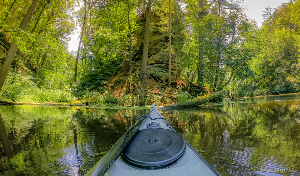
Paddling on Mirror Lake
Time to chill and get out on the water! Whether you bring your own boat or rent one there, paddling on Mirror Lake is the perfect way to take in the unique sandstone cliffs that made Wisconsin Dells famous. It’s a peaceful, picturesque end to your whirlwind tour of our region’s natural wonders.
Mirror Lake Boat Rental Information (No reservations needed for kayaks, canoes, sups)
From the boat launch, simply paddle straight across the lake (west) and into the sandstone canyon following Dell Creek. Mirror Lake is “no-wake,” so you’ll find this to be not only beautiful but relaxing as well as you take in the sandstone cliffs rising from both shorelines.
After paddling through a beautiful sandstone canyon, you’ll exit out into Pickerel Slough, a favorite birding location during migrations. On a good day, you’ll see every sort of duck, geese, swans, and sandhill cranes in the slough! If you’re feeling adventurous, you can continue to navigate up Dell Creek and see how far you can make it before the water becomes too shallow or overgrowth blocks your path. Eventually, when you’re ready to call it a day, turn around and head back.
Hiking Alternative
If you’re not big on being out on the water, then we’d suggest hiking the Echo Rock and Ishnala Trails. This loop will take maybe an hour, but again, you’ll have a chance to enjoy the amazing sandstone formations that make Wisconsin Dells so special. We also recommend hiking the Bluff-Canyon Trail as well.
Mirror Lake State Park Trail Map
Whichever way you do it, you’re going to be tired by the end of the second day. (It will only take about 15 minutes to drive back to Baraboo.) Along the way, you’ve played in Devil’s Lake, and seen rocky canyons, amazing vistas, open prairies, rolling hills, a waterfall, petroglyphs, ancient islands, wildlife, and of course, the Dells of Wisconsin. Oof!
But in our area, this is only scratching the surface.
Runner-Ups
Here are our “runner-ups” that didn’t quite make this itinerary, but should still be on your radar:
Gibraltar Rock State Natural Area
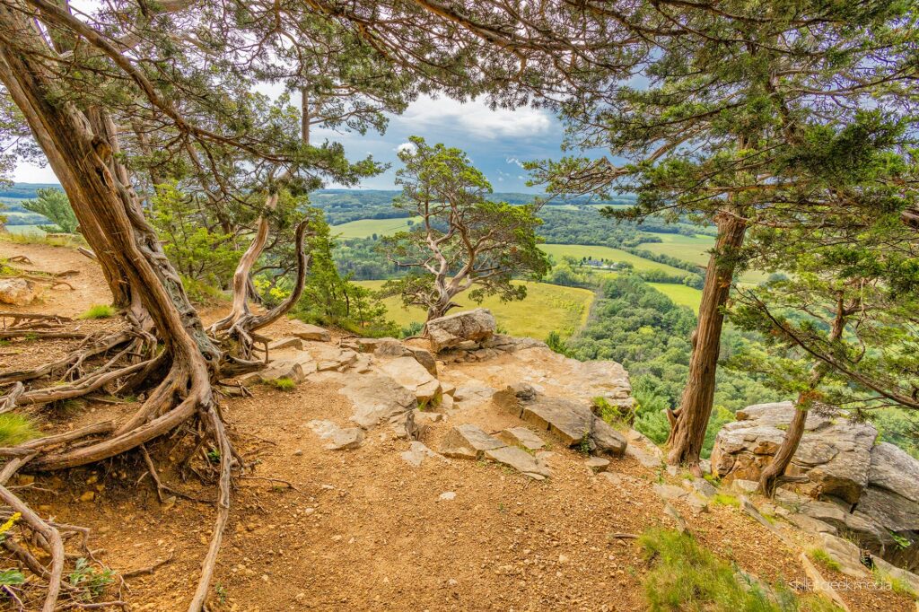
Gibraltar Rock State Natural Area near Lodi offers some of the most spectacular vistas in the state. It’s about 68 acres in size and is located on the 1,000-mile-long Ice Age Trail. The Gibraltar bluff stands some 1,234 feet above sea level, while its sheer 200-foot cliffs offer an amazing view of the Wisconsin River valley.
Pro tip: Take the free Merrimac Ferry across Lake Wisconsin to hike this location. More Info. For dining or drinks near Gibraltar, check out Fish Tales Restaurant on Lake Wisconsin.
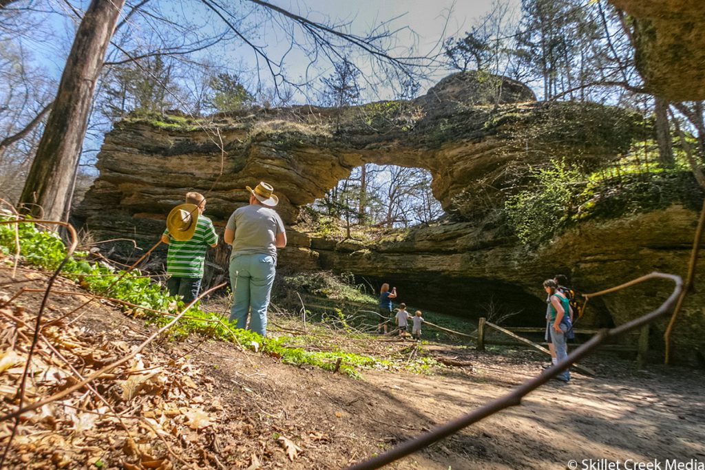
Natural Bridge State Park
Natural Bridge State Park has a natural sandstone arch created by the eroding effects of wind and water. The bridge opening is 25 feet high by 35 feet wide. This weathered formation was missed by the glaciers during the last Ice Age. Near the bridge is a rock shelter used by native people when the glacier was melting, 11,000 years ago. More Info
Side note: There is no restroom (to date) at this out-of-the-way location, which means folks often leave TP around the parking area. (So, “Go” before you go!)
Remember, this is just a taste of what our area has to offer. There’s always more to explore, but we hope this gives you a good mix of unique landscapes and experiences that begin to show you the diversity that central Wisconsin has to offer. Happy exploring!
Does this 2-day itinerary sound like a great way to see the most diverse landscapes of our part of the state? Would you choose different locations? Which ones? What are your recommendations?

For nearly 2 decades the Skillet Creek blog has focused on 3 main goals; To inspire you to visit and explore the Devil’s Lake region, to help you get the most your visit by sharing tips, events, and other helpful information. Lastly to advocate for our environment & wildlife and talk about how we can keep our natural areas amazing now and into the future! That last goal can sometimes cause controversy, but it’s the only way we can accomplish the first two. – Derrick Mayoleth, Owner.
Related Posts